Friday, June 30, 2017

Sao, Jorge, Azores - Walk 3: Pico das Caldeirinhas to Faja do Ouvidor via Norte Grande

The morning of our third full day on Sao Jorge dawned with clouds, sun and a maddening ache in my quadriceps. The descent yesterday did my legs in. Fortunately the hike today would, we believed, be on good tracks and be gentle as far as descents were concerned. We hope the  mixed sky wouldn't hinder views but you get what you get. 


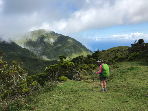
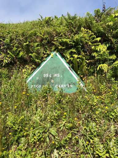
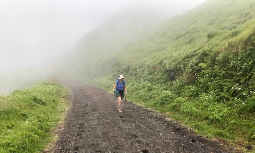
At 09:50 at a spot in the center of the island about 840m above sea level we began our hike. Clouds were above and below but thin and moving fast. Views would come and go. As one passed by I watched a mountain fade from  view in 10 seconds as clouds blew in. A few minutes later it was visible again. We walked along a cinder-bed mountain road between numerous volcanic cones. Little signs noted the names and heights of these mountains as we went by. If we weren't looking at the mountains we might be gazing at high pastures. Now and then the clouds below would clear and views of the coasts below would spring forth. The changing sky made things more interesting as far as we were concerned.  

It's an easy hike along the road. You can focus on the scenery instead of your feet. Besides the grand views that came and went you could find all sorts of wildflowers blooming. The morning was thoroughly pleasant.  


 We made excellent time. Just after 11:30 we had reached Pico da Esperança. Superb time. Inntravel suggests not going all the way up as the trail becomes muddy so we only went about 400m and the view a dry caldera was fine. The sun was shining and the lower clouds had cleared enough to give us more great views of the land and sea below. A lovely morning. 


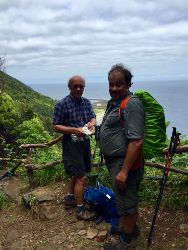
We had hit the highest point of our walk. Now it would be all downhill: 1,025 meters down over the remaining 12.5km. We expected it to an easy walk continuing the cinder track. We had the hills pretty much to ourselves, though two French women would leapfrog with us all the way to Norte Grande.


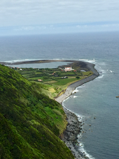
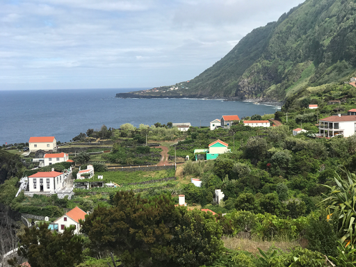
By the time we hit the more-or-less halfway point for lunch it was just past 12:30 and we felt pretty smug that our walk was going so well. Down we strolled passing more fields and mountains and getting clearer views of the north coast below. A little before 15:00 we strolled into the village of Norte Grande and paused for refreshments and to visit the 4 year old eco-museum. They're definitely trying to get people, certainly kids, interested in the natural world of the Azores. 


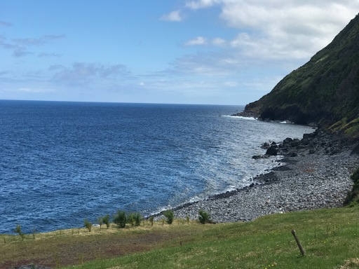
We could have stopped here but instead continued on. 2km more to reach  Faja do Ouvidor. If we had only known then what we do now. Maybe there is a nice natural swimming pool and a cafe someplace else (not likely) that is open. What we found was an awful 160m descent on a path a bit over 1km long that was steep,  strewn with rocks and not even pretty, which made this bit painful to the quads and just not worth it; a come down after such a fine day. At about 17:10 we piled into the taxi to head back to Velas. We spent a lot of the time driving through clouds. By late afternoon a low overcast had settled on that part of the south coast. We did much better where we were I think. But if I do the hike again I'll skip Ouvidor


About the Photos

Signs like this one in photo 1 appear now and then to tell you what the volcanic cones are. 

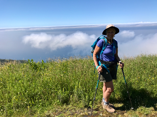
Clouds came and went throughout the morning and early afternoon. Here mom is coming out of a cloud in the photo too.


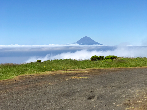
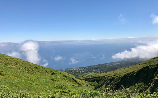
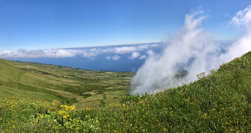
We have clouds above us and below us it made for a spectacular views as you can see in the next few photos. Photos three shows the island of pico in the distance.


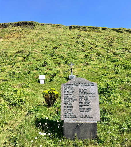
Photo 4 is a monument to the people who died when a Sata airplane on its way to Faial struck here. 


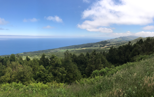
Photo 5 looks out on the south coast. We are approaching Pico da Esperança and it is a great day. 


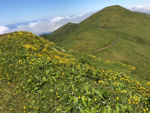
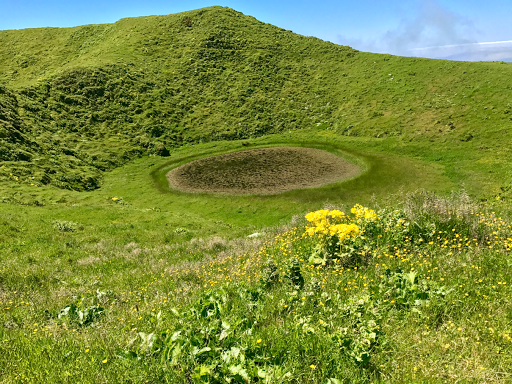
Photo 6 through 8 show Pico da Esperança on the way up looking back; the place we stopped to love k at a caldera; and a view of the north coast of Faial. 


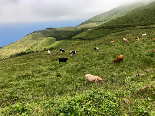
Photso 9 and 10 are just fine views of life up in these higher pastures and our lunch spot. 


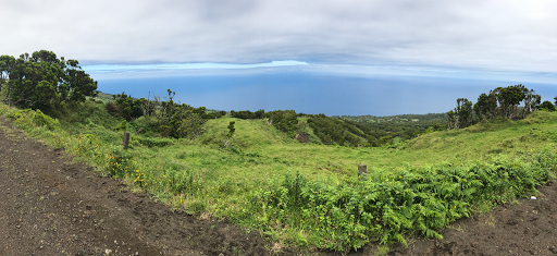
The last two photos show us getting closer to first  Norte Grande and then the village of Faja do Ouvidor

Tuesday, June 27, 2017

Sao Jorge, Azores - Walk 2 - Piquinho da Urze to Faja dos Cubres

My quads are sore. The walk today was just 9.25km but it was a tougher hike than walk 1. We hiked from the top of a valley (700m) to the sea. Along the way we were reminded a bit of the Milford Track in New Zealand. We even had a spot of rain at the start. 


Clouds hung low over the island. Fog and clouds are common and all their moisture  helps make Sao Jorge quite green. It also obscures views. We couldn't see Pico this morning. Today's hike has views but initially you walk down into a valley through forest with just occasional panoramic views.  So it was a better choice than the other option for today(which we will do tomorrow) which is noted for vistas. 


After a 35 minute drive everyone, including two other couples doing the same trip as we, were dropped off at the starting point: along a road at a bus stop in the heart of the island some 700 meters above sea level. 

into the valley 

We quickly learned this would be a "hike". We stepped on to a trail, certainly not as wide as a well built stretch of North Country Trail or trails in the High Sierras or the Milford Track. Hemmed in by forest and the edge of the mountain this trail had numerous rocks and roots. Slippery footing. Inntravel reckons you will move at 2kph and I'm sure that's accurate. Sadly, given the footing and steepness of this narrow trail my speed was a lot less and my work harder. It's a lovely descent into the valley but it's hard to enjoy when struggling down slippery rocks that bother even sighted people a little.  The cows who use this path must be hardy beasts. 


Over the next 5km we dropped down to the sea. There were places that were gentle and the footing changed to a gravel-like substance. A stretch around 2km that ran near rivers was almost flat as it slowly went downhill. But this is a tiring trail and we were well behind. We didn't take little side trips to a waterfall which was probably quite pretty. 


lunch spot 

looking NCT spot shorelines me view 

It's  a dry  lush valley and if the mountains had had water pouring off them the comparison to scenery in New Zealand would have been greater. At about 14:30, under now party cloudy skies,  we reached the coast. The hardest bit was done. Our path was now a coastral track just wide enough for a quad (4wheeled vehicle)to drive on. Many do. It's how the villagers in the 5 home village of Fajas do Belo (or was it Santo Christopher) bring in supplies to the their homes with their stone wall corrals. The track is hard surface. Maybe old lava, they refer to cinder in the directions, and easily walked but for the small hills you must climb. Each is I think about 20 meters high and while not as steep as the hill to the lookout tower of the day before they're steep enough. But the views of the cliffs, small fields and the ocean pounding the shore were lovely. 


Village on the coast 

cliffs of Fajas dos Cubres 

A little before 15:00 we reached Faja de  Cubres. A small village that felt busy and alive. It's a starting and ending point for tourists. We settled in for sodas and to wait for our drivers. Since they came early we left early for the 40 or so minute drive back. Enough time to get good and stiff. It is a walk worth doing but especially the first 3.5km to our lunch spot are a quad and knee killer. 


About the photos

The first photo is one of our few "big mountain" views and came early in the walk. 


The second and fourth photos are our lunch spot. At this point we're still about 140 meters above the sea. 


A gravel-based steep path would drop us down to the coast and the location of the 5 house hamlet you see in photo 3. They have a church too. 


The last photo looks back along  the coast from Faja da Cubres. 


The first and last photo were taken by Ken; Mom took the rest. 

Monday, June 26, 2017

Sao Jorge, Azores - Walk 1: Sete Fontes-Lighthouse-Ponta Rosais/'-Sete Fonte


After a fitful nights sleep I joined Mom and Dad for our first breakfast here at the Casa do Antonio in Velas, Sao Jorge, Azores, Portugal. It was a simple continental affair: tasty enough but I think I'll miss hot items. The morning was bright and clear. The loudest things were some birds, a couple of nearby barking dogs and some modest sounds of a small town quietly waking.  It was quieter, less intrusive, than the  live music that rolled across town ending at 02:15 with Purple Rain by Prince. I suspect Velas never gets too busy.  


Jorge, our Inntravel driver, arrived promptly at 09:30 to take us to Sete Fontes, the start and likely endpoint of our first walk. He has a wealth of local knowledge he is happy to share. Within 15 minutes we had passed through a town or two, passed a couple of small herds of cows following their trucks on the road going to new pastures, and drove into the cyprus forest that makes Sete Fontes special. The sun was warm, intense, and we were ready to go. 


The cypress forest was full of life. The baby ducks and their mother had to be the cutest. Watch your step as the ducklings waddle right up to you. Strolling paths abound so there is ample chance to explore. But that would wait until later. We struck out on a dirt road at about 09:50. Our trek was underway. 


Mom and Dad on the two track not far from Sete Fontes 


Ken at the same place.  

Inntravel provides detailed directions.  They described our starting spot almost perfectly. When the directions say to expect a track on the right bounded by hydrangea hedges on the left and a dry stonewall on the right in  500 that is what you will find. On either side pastures roll into the distance. You descend ever so gently on a two-track path. Hydrangeas bloom but other flowers appear from time to time. Now and then cows appear. Bales of hay ferment under black plastic lending a distinct aroma to the air. In time you catch views of the deep blue ocean a couple km distant and few hundred meters below.  The walking is easy. The surrounding quiet. It's not wilderness by any stretch but we all relaxed as the morning progressed and we strolled along the tracks northwesterly towards the end of the island. 


A high point  of the walk is an extension some might skip but shouldn't. It adds 1km each way but it's easy walking. The lookout tower is some 20 meters above the track on a hill. That ascent happens quickly. I'd not be surprised to learn the steep concrete walk with its wooden handrails was only about 150 meters long: the directions from Inntravel said steep and steep it was. The views are worth the climb. Just a little further on is a now automated lighthouse. Before 1980, and a large earthquake, lighthouse keepers lived there in concrete buildings that clearly are far newer than the original lookout. Originally , in the 19th century during the hey day of whaling, a lookout tower was there for whale spotting. Here we met our first people. A French couple, staying at our hotel, pulled up to us in their car that they had hired for touring the island. As we left the northern tip of the island we saw a handful of other walkers coming. A km or so later well other 30 Germans passed by doing the loop in the opposite direction. 

overlo k 1 


overlook 2 


Our views of fields and surrounding seascapes continued. After a tiny bit of uncertainty about which track to take, we continued through a stand of trees and  found a spot with a view. The food, provided by the hotel, was mediocre.


By now it was early afternoon. The clear sky was being overwhelmed by a high overcast. The temperature was in mid 70s. We reached a cafe mentioned in our directions and had packaged ice cream treats and sodas. How do they survive in this minuscule clutch of very modest seeming homes?  After the cafe break, where there is the option of ending the hike, we decided to assault the steep climb to Sete Fontes. 


The climb is very steep.  The grade is in the 15% range. In somewhat less than 1km you climb 150 meters. It took us just under 30 minutes. But then you pass into a Cypress forest and cow-filled fields which is a real treat. It was a much nicer place to wait for Jorge to pick us up than the hole-in-the-wall  cafe. 


All told this was a 13km walk along easy tracks. The 150 meter climb at the end is steep but it's the only steep bit. You'll notice a gentle climb after leaving the lighthouse but nothing to remark upon. This was a good first walk. 


About the photos


The first two photos are taken only a few hundred meters into the walk. We have entered a section of track that has numerous hydrangea hedges and stone walls. Stonewalls and hydrangeas, along with other flowers now and then, are signature features of the walk. The first photo features Judy and Jonathan; the second photo Ken


The next three photos are taken from the top of the lookout tower near the northern tip of the island.  Well worth it even though you do have to climb a steep hill to reach the tower. First looking generally southwest is Pico. Next the lighthouse complex a short distance away at the tip of Sao Jorge. Finally, looking north easterly. I didn't take a picture South easterly because that was peering into the sun. 


The last picture comes to give you a sense of just how steep the concrete path to the lookout tower is. I would not be surprised if the path is about 150 m long and I know rose about 20 m.